
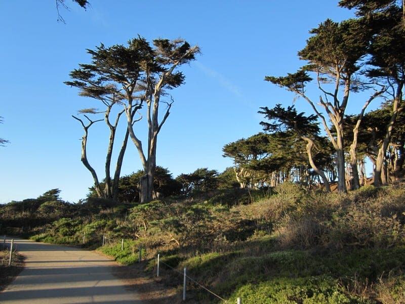
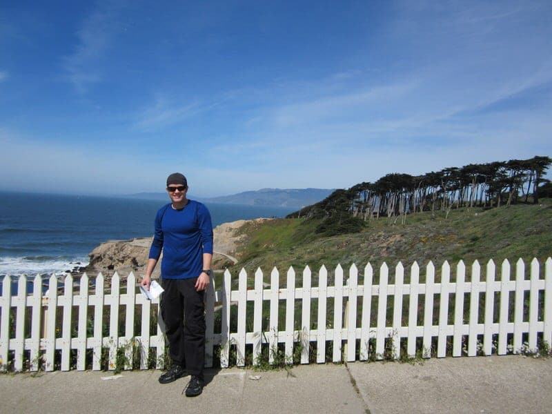
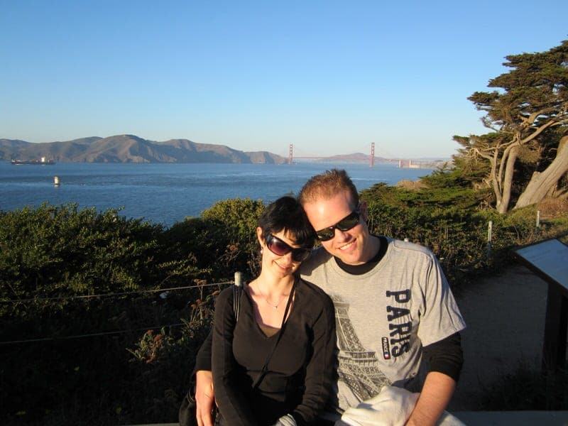
Hiking at Lands End is a great way to explore the rocky northwestern corner of San Francisco. Imagine that you are walking in a wooded area alongside the ocean with spectacular views around every corner—hiking at Lands End makes it easy to forget that you are actually within the bustling city of San Francisco. So far this is one of my favorite short hikes in the Bay area and provides one of my favorite views of the Golden Gate Bridge.
If you stay on the main coastal trail at Lands End it is a very easy hike, but the main trail also connects with other local trails and offers several worthwhile detours for those who have more time and stamina. The trail hugs the coastline and offers views of the historic ruins of Sutro Baths, old shipwrecks, small rocky beaches, a war memorial, and wonderful views of the Golden Gate Bridge among other things. We’ll tell you how to find the Lands End trail, provide some tips on making the most of your hike, and share our experience of hiking at Lands End.

Table of Contents:
Basic Information About Hiking at Lands End
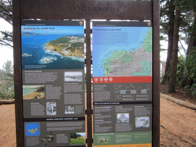
There are actually several trails that go through the Lands End area with the most popular being the less than 2 mile section of the California Coastal trail that snakes along the coast. In my opinion, the Lands End section is one of the more interesting sections of the California Coastal trail within San Francisco. The trail follows approximately the same route as the former Cliff House Railway that used to transport people to Sutro Baths—the largest public indoor swimming pool complex in the world when it opened in the 1890’s. A number of shorter trails spur off from the main Coastal Trail allowing visitors to visit beaches, a war memorial, and even a fine arts museum.
Where?
Lands End is located in the northwestern part of San Francisco and the Land End Lookout Visitor Center is located at 680 Point Lobos Avenue, San Francisco, CA 94121. When looking on a map it is very close to the Cliff House restaurant and Ocean Beach.
How to Get Here?
You can start the hike at a number of places, but I would recommend beginning at the Lands End Lookout Visitors Center, especially if this is your first visit. There is a parking lot located at the Lands End Visitors Center. There is also another parking lot almost directly across the road and more further down near Ocean Beach.
You can also get here by public transportation. The nearest MUNI bus stop to the Visitors Center is located at Point Lobos Avenue and 48th Avenue (Bus 38L). You can check MUNI bus schedules here.
Hours?
While you can still hike the trail when the Visitors’ Center is closed, the Lands End Lookout Visitor Center is typically open Monday thru Friday 9am-5pm and Saturdays and Sundays from 9am-7pm.
Trail Difficulty?
Easy, although if you venture off the main trail you may be walking up and down quite a few stairs and some parts of the trail may be composed of sand or loose dirt/rocks. For instance, I believe there are about 100 steps to get from the trail to the Mile Rock Beach. The part of the trail that goes from the parking lot to the first two viewpoints is ADA accessible – see trail map.
Price?
Free! Although if you want to contribute, you can purchase educational materials or souvenirs from the Visitors Center or ask about ways to donate to the Golden Gate National Parks Conservancy.
More Information?
For the latest Lands End trail information, you can call the Visitors Center at (415) 426-5240 or check out the official Golden Gate National Parks Conservancy website.
Other Tips for Hiking at Lands End
- Hiking at Lands End can be fun at any time, but visibility can be greatly reduced if it’s cloudy or foggy so the views are best when the weather is clear.
- Dress in layers and bring water.
- The main trail does not make a loop as you can see from the Lands End trail map so you’ll likely need to retrace your steps. The time it takes to do the hikes varies depending on a number of factors (starting point, pace, detours, photo stops) so if you only have a certain amount of time, you should be able to easily estimate how long it will take you to return from any given spot. We usually just walk and hike until we start getting tired and then turn around.
- If you are interested in viewing some of the shipwrecks (a few are viewable), do the hike during low tide for the best chance of spotting them. Check out the locations of the shipwrecks using a map from the Visitors Center (there are also some signs posted along the trail).
- You can take a detour onto the El Camino Del Mar Trail to the Legion of Honor (or start your hike here below the museum). The Legion of Honor is a fine arts museum and one we think is definitely worth a visit if you have the time.
- Dogs are allowed on the trail but should be kept on a leash or under strict voice control.
- The Visitors Center offers some interesting educational and historical exhibits which are worth a look. There are also sometimes short film clips showing as well. The staff and volunteers are usually quite knowledgeable about the area and can likely help answer any questions you have about hiking the trail or the history of Lands End.
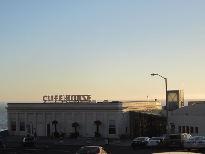
- You have three very convenient eating options: grab something quick at the Lands End Visitors Center Café (operated by the Cliff House), grab a seat at the family-run Louis’ restaurant, or pick one of the two eateries within the Cliff House (The Bistro or Sutro’s). The café at the Visitors Center and Louis’ restaurant are both hiker, wallet, and child friendly, whereas the Cliff House offers more ambiance but at a greater price.
- If you want to picnic instead, the nearby West Fort Miley batteries offer a grassy picnic area among three turn-of-the-century gun emplacements.
- If you have time, walk down to the Cliff House (even if not eating here) and view some of the photos of the old baths located inside. Outside you can walk down and around the Cliff House for some good views. Seal Rocks is the name of the little rocky “islands” and if you look through one of the telescopes along the water you’ll probably get some good views of some birds and sea lions.
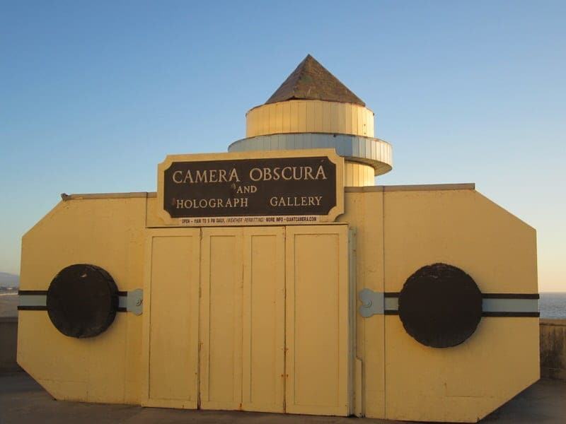
- Located outside and behind the Cliff House (head down the steps to the lowest level) is the Camera Obscura, which is a giant viewing camera device based on a 15th century design by Leonardo da Vinci. It is $2 per child or $3 per adult and is worth a view if the weather is clear. Open 11am-5pm each day when the weather is clear as it needs light rays to function properly.
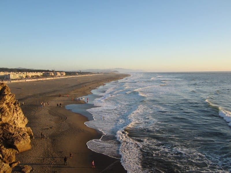
- The beach next to the Cliff House restaurant is Ocean Beach. If you have time, it is a fun place to relax, people watch, swim, boogie board, or surf. Although remember the water is almost always cold in this part of California so if you plan to boogie board or surf, you’ll probably want to get a wet suit.
Our Experience of Hiking at Lands End
We have hiked and walked around Lands End both alone as a couple, with a friend, as well as with visiting family members. So far we have always been lucky at securing a parking space at the Lands End Lookout Visitor Center or the parking lot almost directly across from the Visitors Center. The Visitors Center was only recently opened and contains free information, some exhibits on the history of Lands End and the area, some short video presentations, bathrooms, souvenirs and educational materials for purchase, and a café. During our first visit, we picked up a free trail map and asked one of the friendly staff members some questions about the trails before setting off on our first hike. The facility was very clean and well-maintained during our visit.

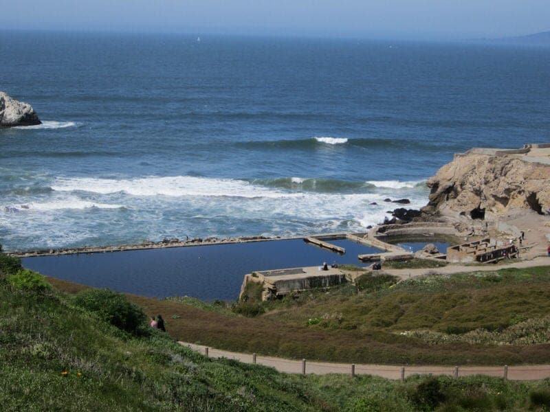
For our first stop, we followed the trail downward to explore Sutro Baths (left from the Visitor Center parking lot when facing the water). If you have any mobility issues or are very short on time, you can get a very good view of the Sutro Baths from the top of the hill or you can walk down along the sidewalk along Louis’ Restaurant for a gentler incline. You are able to look at the ruins close up and even climb around on them if you want. Recently, a river otter has taken residence in Sutro Baths and if you are lucky you may spot it. We have yet to spot the famous resident. There is also a short cave that you can venture into on your right when facing the water, which offers some decent photo opportunities if you walk to the very end of the cave and look out.


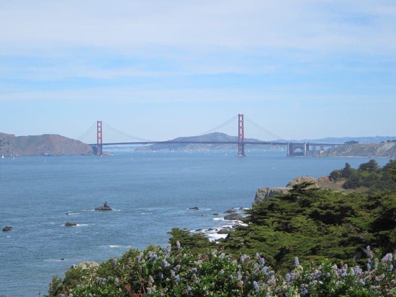
Next, we left the cave and walked back up the path to the parking lot (you can also take an upper trail above Sutro Baths for additional views) and joined the trail that starts at the corner of the parking lot. This is an easy paved walk and along the way there are some interesting placards that provide history on the original inhabitants of the area, the history of the baths and steam train that used to be located at Lands End, the flora and fauna, shipwrecks, and other interesting information. After about 10 minutes you’ll come to the first Lookout point (Lifesaving Station Overlook) which offers wonderful views of the Golden Gate Bridge. This is a great place to stop and take some photos.

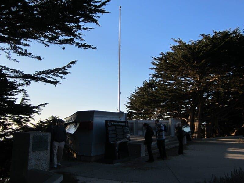
If you venture up the steps on the hill to the right from this lookout point, you’ll come to a parking lot and the U.S.S. San Francisco Memorial. The history of the U.S.S. San Francisco and its crew which fought against the Japanese in World War II is quite interesting. If you visit the memorial, just climb back down the steps to rejoin the trail. If you are short on time or low on energy, you can stop here and just head back to the Visitors Center but if not, you can continue on to the second lookout (Mile Rock Overlook) for more great views.
At points, you’ll see signs for detours onto other trails, such as one to Mile Rock Lookout Trail. Ethan and I headed here for the view and to visit the Mile Rock Beach. There are a number of stairs to get to and from the beach, but after all the steps we climbed up onto a couple of the giant boulders and decided to take a break and read. The sun was out and it was wonderful!
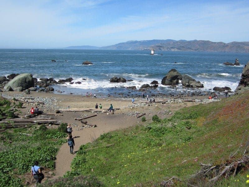

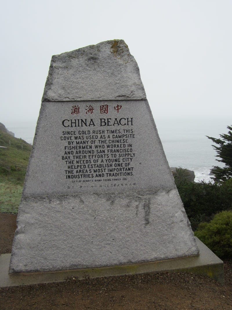
While we decided to turnaround and start retracing our steps after this detour to Mile Rock Beach on that hike, you can continue on further and take a detour to the Palace of the Legion of Honor, continue on the trail for Eagle Point Outlook (this is where many people decide to turn around), or continue further and make a detour to China Beach. If you want to keep heading to China Beach you’ll come to the end of the trail at this billboard.
To get to China beach, keep going and follow the sidewalk that will go downward into a residential area. You’ll keep following this pass a lot of nice houses until you eventually (about a 10 minute walk) come to a sign that will points to China Beach. You’ll take a sharp left to join the road going to China Beach and pass the small parking area for the beach and come to the China Beach monument. You can then take the steps down to the beach. Depending on the time of year and day, you’ll likely spot surfers and fishermen in the area.

If you keep going past this, it is possible to reach the Golden Gate Bridge although this is a fairly long trek. We’ve never gone past China Beach.
During all of our visits, we have really enjoyed the wonderful views and well-kept paths at Lands End. We continue to enjoy relaxing at the little beaches, searching for the otter at Sutro Baths, and learning about the history of the area as we walk along the trail. If you are in San Francisco and want to get a break from the city, this is a wonderful way to do it.
Questions about hiking at Lands End? Have extra tips for us from your experiences of hiking at Lands End or have other nearby trail suggestions? We’d love to hear from you.
Julie Roy Post author
Lovely hiking post about Lands End! Love your excellent information for hiking these beautiful place in San Francisco. I am influenced by your wonderful experience and beautiful pictures shared with us. I am so excited to visit San Francisco next vacation with family.
Cheers!
Jessica & Laurence Norah Post author
Hi Julie, Glad you enjoyed our post and hope you get a chance to do the hike at Lands End when you visit San Francisco with your family! It is a beautiful hike, especially on a sunny day! Best, Jessica
Cat McMahon Post author
I really enjoyed a vicarious hike with you, Ethan and Jessica. What a lovely post! I felt like I was there experiencing the sights, sounds and tastes with you. I love the format of your post, too. I’ll be printing this one off to take with my on my next trip to San Francisco!
travelcats Post author
Thanks Cat, we are glad you enjoyed the post. It is really a lovely place and I hope you enjoy it during your next visit.
Meghan Post author
Your pictures make me miss living on the west coast…sigh. I’ll have to check out this hike next time I’m in the Bay area! Thanks for sharing!
travelcats Post author
Living on the West Coast definitely has its advantages, but I am sure there are great hikes everywhere in the country!
Amy Post author
Have you hiked north of the Golden Gate in the Marin Headlands? Not as rocky but still beautiful. You have inspired me to take the time to explore this area next time I am in the “City” . I have been to Cliff House, nearby beaches, and Fort Point but not Lands End.
travelcats Post author
Hi Amy, we have spent some time walking/hiking around Sausalito in Marin County but nothing extensive. If you have some hiking tips, we’d love to hear them. If you haven’t been to Lands End, I would highly recommend, it makes for a great low intensity hike with million dollar views:)
Amy | Club Narwhal Post author
What a beautiful place to hike! I love the views you guys took in. And this makes me want to visit San Francisco immediately 🙂
travelcats Post author
Thanks Amy, Lands End is such a beautiful place to have so close to the city. You’ll have to come visit!
Nicole @ Treasure Tromp Post author
this looks incredible!! I need to do this hike when I’m in SF
travelcats Post author
Yes, we were so surprised to find such a beautiful trail in the city!
Louisa @ My Family & Abruzzo Post author
That looks like the beach from the ending of The Goonies. Don’t know if it is or not, but thought I’d put it out there. : / Lovely pics and place to hike.
travelcats Post author
Um, I think I know what you are talking about but it has been a long time since I’ve seen the Goonies! A great hike if you are ever in the SF Bay area.
Melissa Post author
I lived within a 5-minute walking distance from Lands End and I can’t stress enough about how this trail is San Francisco’s most beautiful jewel. Your pictures bring back a lot of wonderful memories – thank you for that!
travelcats Post author
Oh my goodness, really! Lucky you for having lived so close. I hope you get to come back and do the hike again. It had definitely changed some with the park trying to make improvements and make it more accessible.